NASA-ISRO Successfully Deploy World’s Largest Radar Antenna in Orbit
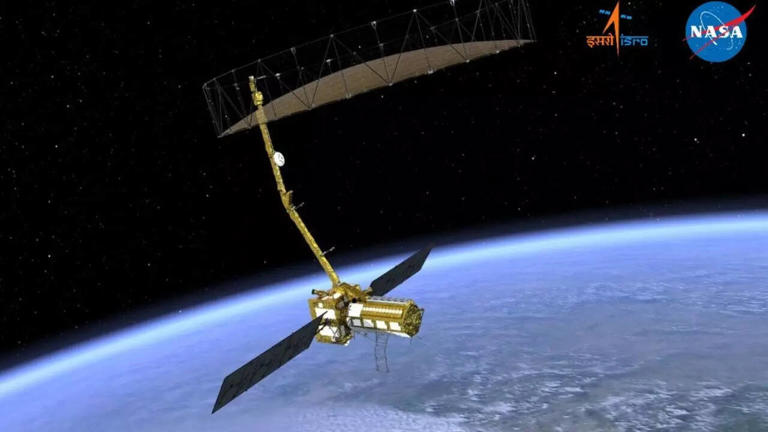
In a monumental step for global space collaboration, NASA-ISRO successfully deploy world’s largest radar antenna in orbit, marking a new era in Earth observation. The 33-foot antenna, part of the NASA-ISRO Synthetic Aperture Radar (NISAR) mission, now orbits about 460 miles above Earth.
This joint mission between NASA’s Jet Propulsion Laboratory (JPL) and the Indian Space Research Organisation (ISRO) is designed to capture high-resolution radar images that can penetrate clouds and operate seamlessly day and night. With this milestone, scientists, policymakers, and disaster-response teams worldwide gain a powerful new tool to monitor climate change, natural hazards, and agricultural cycles.
NASA, ISRO, and NISAR: Redefining Earth Observation
The NISAR satellite is equipped with dual-frequency L- and S-band synthetic aperture radar. Unlike traditional optical satellites, which depend on sunlight and clear skies, NISAR provides continuous and reliable data under all weather conditions.
Key benefits include:
- Monitoring glacier movement and ice-sheet melting.
- Tracking deforestation and forest regeneration.
- Observing seismic activity and tectonic shifts.
- Supporting agricultural monitoring to improve food security.
According to NASA, this technology will revolutionize disaster preparedness and resource management, enabling nations to respond more effectively to natural and man-made challenges.
Engineering Marvel: The 33-Foot Antenna
At the heart of NISAR’s mission lies its 33-foot radar antenna, the largest ever used in a NASA Earth science mission. Built by Astro Aerospace, a Northrop Grumman company, the antenna was compact at launch and expanded into an umbrella-like structure once in orbit.
Designed to withstand intense launch vibrations, the vacuum of space, and continuous rotation at 4.5 revolutions per minute, this antenna is a true feat of engineering. Its massive aperture ensures the generation of sharp, high-resolution radar images that will reshape scientific research for decades to come.
Synthetic Aperture Radar: Seeing the Unseen
Synthetic Aperture Radar (SAR) works like a supercharged camera lens, simulating a much larger antenna to produce highly detailed images. NISAR takes this technology a step further by using interferometric techniques, allowing scientists to compare radar images over time and create 3D models of Earth’s surface changes.
This groundbreaking capability will:
- Detect land subsidence before it becomes dangerous.
- Identify early signs of landslides.
- Monitor glacier retreat and sea-level rise.
- Support urban planning and infrastructure resilience.
In short, SAR enables us to “see the unseen,” giving humanity the ability to track changes invisible to the naked eye.
Global Benefits of Open Data
One of NISAR’s most impactful features is its open data policy. The mission’s findings will be freely available to scientists, governments, and humanitarian organizations around the globe.
This open-access approach means:
- Farmers and agricultural agencies can track crop cycles more effectively.
- Disaster-response teams can forecast hazards with greater precision.
- Policymakers can make informed decisions to combat climate change.
With Earth revisited every 12 days, decision-makers will have access to timely, actionable insights that strengthen global resilience against climate and environmental challenges.
Why NASA-ISRO’s NISAR Mission Matters
The successful deployment of the world’s largest radar antenna in orbit is more than just an engineering milestone—it’s a testament to international collaboration. The partnership between NASA and ISRO demonstrates how combining resources, expertise, and technology can lead to groundbreaking achievements with global impact.
This mission is expected to: Read Also Latest Tech News
- Improve early-warning systems for earthquakes and floods.
- Enhance sustainable agricultural practices.
- Support climate adaptation strategies worldwide.
- Inspire future collaborations in space exploration.
FAQs About NASA-ISRO’s Radar Antenna in Orbit
1. What is NISAR, and why is it important?
NISAR is a joint NASA-ISRO satellite mission equipped with a 33-foot radar antenna that provides high-resolution Earth observation data to monitor climate change, natural hazards, and agriculture.
2. How does the radar antenna work?
The antenna uses Synthetic Aperture Radar (SAR) technology, which captures detailed images of Earth’s surface, even through clouds and darkness.
3. Who built the radar antenna?
The antenna was built by Astro Aerospace, a Northrop Grumman company, known for creating advanced deployable space structures.
4. How will NISAR data be used?
The data will be available for free to scientists, governments, and disaster-response teams to track environmental changes and improve disaster preparedness.
5. How often will NISAR capture Earth images?
NISAR will revisit the same areas every 12 days, providing continuous updates on Earth’s dynamic changes.
6. How does this benefit everyday people?
From improving food security to enhancing disaster readiness, the mission’s data will have a direct impact on communities worldwide.
Conclusion
The NASA-ISRO successful deployment of the world’s largest radar antenna in orbit is a landmark in space science and international cooperation. With the power of Synthetic Aperture Radar and an open data policy, NISAR will transform how humanity understands and responds to Earth’s changes.
This mission isn’t just about exploring space—it’s about protecting life on Earth and building a more sustainable future.